Sunday 20.7.25
- Alan Jones
- Jul 20, 2025
- 3 min read
Today, Sunday, July 20, 2025, the UK is experiencing a notably unsettled weather pattern, dominated by low pressure.1 The Met Office has issued a series of warnings across various regions, highlighting the potential for significant disruption due to heavy rain and thunderstorms.2
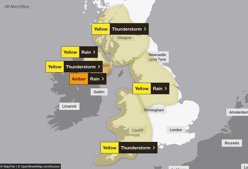
Amber Warning in Northern Ireland
The most severe warning in place is an Amber warning for rain affecting parts of eastern and southeastern Northern Ireland. This alert, valid from 23:00 BST on Sunday through to 08:00 BST on Monday morning, signifies a high likelihood of significant impacts.3 Forecasters anticipate very heavy rainfall, with 50-75 mm possible in a short period.4 Such intense downpours carry a considerable risk of flash flooding, which could lead to difficult driving conditions, road closures, and even danger to life from fast-flowing or deep floodwater. Homes and businesses are likely to be flooded, causing damage, and there's a good chance some communities will become cut off by impassable roads.5 Delays and cancellations to train and bus services are also likely, along with potential power cuts and loss of other essential services.6 The Met Office advises residents in these areas to stay vigilant, check flood risks for their properties, and avoid unnecessary travel, especially during the peak of the heavy rain.7
Widespread Yellow Warnings Across the UK
Beyond the Amber warning, numerous Yellow warnings for both rain and thunderstorms are in effect across large swathes of the UK, indicating that while less severe, these conditions could still cause considerable disruption.8
Rain Warnings:
A Yellow warning for rain covers much of the North West, North East, East Midlands, West Midlands, Yorkshire & Humber, and Wales.9 This warning, generally valid from late morning on Sunday until 22:00 BST, highlights showery outbreaks of rain, which could be heavy and thundery in places.10 Accumulations of 10-20 mm are expected fairly widely, with isolated spots potentially seeing up to 40 mm in just a few hours.11 This could lead to localised surface water flooding, affecting bus and train services, causing longer journey times due to spray and flooding on roads, and potentially leading to the flooding of a few homes and businesses. Some interruption to power supplies and other services is also considered likely.
A broader Yellow warning for rain also encompasses the entire eastern half of Northern Ireland, extending from 18:00 BST on Sunday until 18:00 BST on Monday evening, reflecting the ongoing unsettled conditions in the region.
Thunderstorm Warnings:
Thunderstorm warnings are particularly prevalent. Wales and parts of the South West of England remain under a Yellow thunderstorm warning until 22:00 BST on Sunday.12 This warning predicts scattered heavy showers and thunderstorms, with rainfall amounts varying, but 20-40 mm possible within a couple of hours in some locations.13 The primary hazards include heavy downpours, but lightning strikes, hail, and gusty winds are also possible, leading to difficult driving conditions, potential road closures, and a slight chance of power cuts.14
Further north, large parts of Scotland, including Central, Tayside & Fife, Highlands & Eilean Siar, and SW Scotland, Lothian Borders, Strathclyde, are under a Yellow thunderstorm warning from midday until 22:00 BST on Sunday. Similar impacts are expected, with heavy showers and thunderstorms potentially leading to localised flooding and disruption.
Looking ahead to Monday, July 21st, Yellow thunderstorm warnings are already in place for large sections of England and Scotland, including the East of England, London & South East England, South West England, and much of the Midlands and Northern England, as well as parts of northern Wales.15 These warnings, generally valid from 11:00 BST to 21:00 BST, anticipate scattered heavy showers and thunderstorms, with 30-50 mm of rain possible within a couple of hours in some areas. These conditions could lead to difficult driving conditions, road closures, and disruptions to services.
In summary, Sunday, July 20, 2025, is a day of widespread weather warnings across the UK, with the primary concerns being heavy rainfall and thunderstorms.16 Residents are strongly advised to stay updated with the latest Met Office forecasts for their specific areas, exercise caution, and be prepared for potential travel disruptions and localised flooding.
Visit MetOffice for more.


Comments